Sunday, June 6, 2021
Friday, June 4, 2021
Dark Canyon Wilderness Loop
On the second week of May, Libby and I set out for our annual spring desert backpacking trip. Although we love the Swell, we chose to venture further south to Bears Ears. On this trip, we traveled through all types of desert terrain and saw some of the most intact dwellings/ancient structures that we've ever seen. On top of that, we spent the entirety of each day moving and got stoked for more remote adventures in the upcoming warm months. Backpacking continues to be a great way for Libby and I to press the reset button on our lives and reconnect with ourselves and each other.
As Utah residents, we are incredibly fortunate to live only a short drive from some of the finest desert country in the world. These areas are vital for our wellbeing and their intactness preserves a heritage that Europeans spent years nearly eradicating. I always leave these trips feeling a tremendous amount of respect for the desert and whomever made it work for themselves in this unforgiving environment. Moreover, each trip into the desert makes me feel like this "public land" is not ours even though we as citizens technically own it. Indeed, I feel much smaller within the backdrop of the Intermountain West and know that I'm only a visitor in spaces such as these.
Travel was from the Woodenshoe Canyon, up Dark Canyon, and out Peavine Canyon. I didn't record our track, but I estimate the total stats to be around 4,000-5,000 feet of gain and anywhere between 45-50 miles. We completed the trip in roughly 3 days and we felt we moved quickly. With trips like these, we always wish we had more time to stop and explore.
Albeit a bit late due to a trailhead snafu, we started down Woodenshoe Canyon, which was dense and had some massive ponderosa pines.
We had lunch during the heat of the day at the confluence of Cherry and Woodenshoe. After eating I poked around looking for dwellings but couldn't find anything. We were out of the dense pine stands at this point.
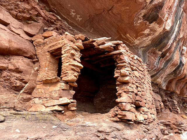
Libby spotted this dwelling from the trail a ways between the Wates Pond area and Cherry Canyon.
Note the wooden beams and the windows. Incredibly intact.
I had never experienced rain in the desert until this trip. Luckily I brought my pancho. It looked like a weak system so we waited most of it out under a little overhang.
The dirtiest part of the water source at Wates Pond, where we set up Camp 1. A really lovely area.
Toward the confluence of Dark Canyon, the lowest elevation of the hike. Hot, dry, sandy, and eroded, wave-like rock.
Collared Lizard
Dark Canyon is DEEP! We looked up at some of the massive sandstone headwalls and daydreamed about coming back here with a rack and rope for some deserteering.
A granary used to store grains, seeds, and other forage. We looked around and thought about how collecting grains (let alone building storage) would be a massive project. No wonder why the ancestral people who collected them also wanted to protect them. Were these canyons wetter when ancestral peoples lived here?
Camp 2, a bit up-canyon from Trail Canyon. The established campsites were taken by a party of three who decided to spread out, so we had to find our own. We cowboy camped that night, and it was surprisingly cold. Waking up throughout the night and gazing at the stars sweetens the deal.
It started to feel more like 'forest' land once in Peavine Canyon. I wish we could've set up camp in one of the lovely, flat meadows.
Water was scarce on this trip and especially in Peavine Canyon. We sucked from some pretty nasty puddles. It tasted about as good as it looked. Unbeknownst to us, there was cleaner and more abundant water a bit further up-canyon. This was our last planned water refill until the cattle trough that we mistakenly thought was only a handful of miles ahead.
After some miles, we had little water left and were excited to set up camp in a spacious, shady pine grove. We realized that we misread the map and mistook a corral for the cattle trough filled with cool, clear water. This meant hiking up canyon until we reached the cattle trough, which could've been anywhere from 1 to 4 miles. We only had 1 liter of water apiece, which was insufficient for camp and the following morning, so we continued up canyon.
Libby was dealing with some gnarly blisters, so she told me to go ahead and set up up camp once I found the trough. I moved heads down until I could find the cattle trough, but I did periodically look up and appreciate the airy aspen groves in upper Peavine.
Water! And some level space for camp! In my opinion it's poor form to camp this close to a water source, but it was late enough in the evening to assume that no one else would drop by.
We built a small fire and listened to a couple of great Snap Judgment stories before heading off to the tent. We wanted to soak in as much of Peavine Canyon before returning back to civilization.
On the final day, we anticipated easy trail for the entire way back to the trailhead. I was breaking in my new shoes (dumb thing to do on a trip) and wanted some respite, so Libby and I both hiked in our camp shoes. I've got some goofy (but light!) water shoes, and Libby's got some plastic composite Birkenstocks. Nice one.
Upper Peavine was such a treat. Very fine high elevation wooded mesa.
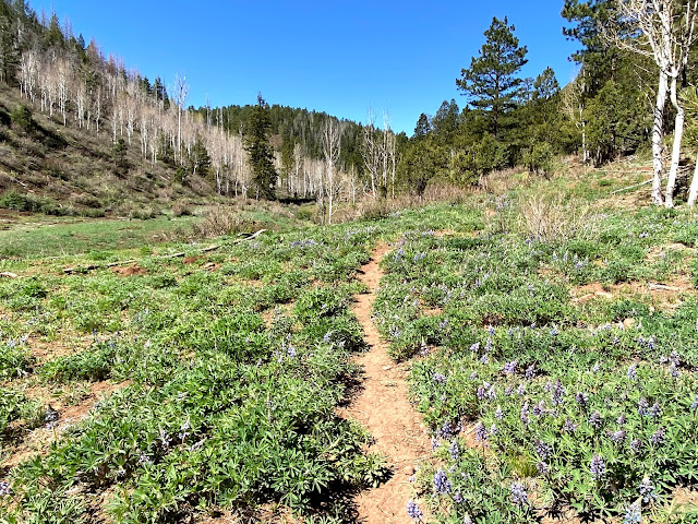
More of the same. Note all of the beautiful lupine. A trail runner's dream.
Aspens in upper Peavine.
We finished up the trip cruising the few miles of the well-bladed FS road back to the Woodenshoe Canyon TH. Spirits were high, but we knew that we would either need to break my car window or figure out a way to unlock the car from the outside. That trailhead snafu I mentioned before? I locked my keys in my truck. I spent a lot of time on the hike thinking about what a dumb mistake that was. Thanks to the inReach, we found out that we were in way too remote of a location to expect the FS or AAA to help us out for cheap.
I really did not want to break my window (we still had lots of traveling to do, including a drive to the Front Range), so we decided to spend a few more minutes devising a way to get into the truck without breaking anything.
Those few minutes were some of the more dramatic in recent memory. After some deliberation, we unlocked the car from the outside! I won't go into detail, but it turns out that all you need is some wire (in our case, cattle fence wire) and a pot scraper.
Victory!
Both of us were overjoyed and we drank the shit out of some cooler-cold beers and soaked up the high desert sunshine.
Next stop: a cheap motel in Durango.
Subscribe to:
Comments (Atom)
Baja Chronicles Pt. 4
May 28-29 "Welp, we decided to punch it up north and hopefully find one last good Mexican wave before crossing the border. Along the ...

-
I knew about the Wasatch Ultimate Ridge Linkup ever since I moved to Salt Lake City in the late summer of 2019. I began "trail running...
-
May 28-29 "Welp, we decided to punch it up north and hopefully find one last good Mexican wave before crossing the border. Along the ...
-
May 26-27 "The other night it occurred to me how there's few places in the States where one can do something very cool in the open...


