Monday, April 12, 2021

Box Elder Peak-NW Couloir


On Saturday, 4/10/21 I rode the NW Couloir of Box Elder Peak. Leading up to the weekend, I obsessed over weather data and the forecast. There were so many question marks and variables involved that deciding on an objective was rather challenging. For instance, a recent storm delivering up to 16" in the Cottonwoods earlier in the week reduced the chances of a nice corn cycle to develop. I confirmed this during a quick tour up Scottie's the Thursday before, where low-mid elevation N/NE facing was locked up and cruddy. (The type of conditions that make you feel like an even worse snowboarder than you actually are) 

After sustained high pressure and a forecasted high of 70 in the valley, I finally settled on Box Elder's NW Couloir. Aside from being in the revered Chuting Gallery (which admittedly adds value to any descent in the Wasatch), the line's position seemed reasonable for the conditions at hand. Hard refreezes overnight, high valley temps, and lots of wind from the SW. I reasoned that the snow in the NW aspect at that elevation would be firm but soft enough for edging in with confidence, and that if I arrived a bit too late it may soften up with afternoon heat. It turns out I was more or less right, although I think we could've waited it out at the top a bit for even better riding conditions. Alas, this was a fun descent and I would say an even more fun approach/egress based on the delightful spring weather and a pleasantly dry trail. 

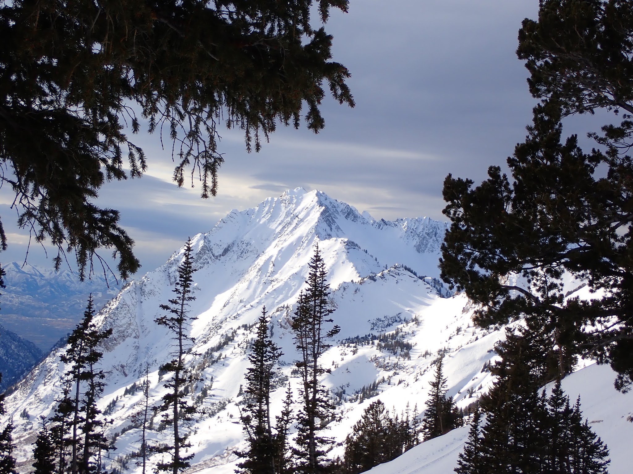
The day started at around 7:45 at the Dry Creek Trailhead just outside of Alpine. The trail walking went fast and we cached our running shoes 2.5 miles. Soon after we were skinning beneath Box Elder's NW Basin with the line in our sights, as well as the south faces of Lone, White Baldy, the Pfieff, Chipman, Bighorn, and the rest of the peaks along that ridge line to our north. 


The White Baldy complex from the south

The Pfieff and Airplane Peak from the south

Chipman, Bighorn, and Lone from the South

We deliberated a bit on Box Elder's lower NW flanks, deciding whether to take the longer but perhaps more tolerable NE ridge to the summit, or go for the more direct NW ridge with the Shotgun Chutes skinner's left. We chose the more direct NW ridge, which was quite the pain in the ass. Suffice to say ski crampons have officially moved up several notches in my late season ski wishlist. Based on the conditions, I think it would have been faster to skin up the NE ridge and take advantage of the snow softening up on those aspects. Even still it wasn't a huge setback-- just annoying. 

After emerging from the trees the skinning improved temporarily, but Box Elder's N ridge was jacked by the wind, so skinning continued to prove challenging. After a while I gave up and threw my aluminum crampons on. I'm sure it was slower than skinning with ski crampons, but it got the job done. 

While working our way to the summit, we eyed a line off of Box Elder's NE aspect. It looked like a mighty fine steep bowl funneling down into a chute and into a cliff band. The snow felt good and soft on this aspect but we both knew nothing about this descent and whether it even went. It'd be fun to scope from the bottom and potentially give this a go on a different day. 


Box Elder's wind jacked N ridge


We were at the top in around 4:30. I'm not sure I could reach the summit much faster than that— especially this time of year with firmer conditions— but who knows. While transitioning I made a blunder and forgot to jam my bindings into the snow. One of them went for a twenty foot ride off of the summit. Just as it sped further down and potentially into the ether, I made a diving catch (crampons on) and saved it. Dumb, dumb, dumb. Lesson learned: nothing comes out of the pack on a summit unless it's firmly planted in the snow. If I lost that binding, managing the descent may have been all but impossible. I do carry a passel of Voile straps, so maybe there could've been some solution. I shudder to think of what that would've looked like though. 

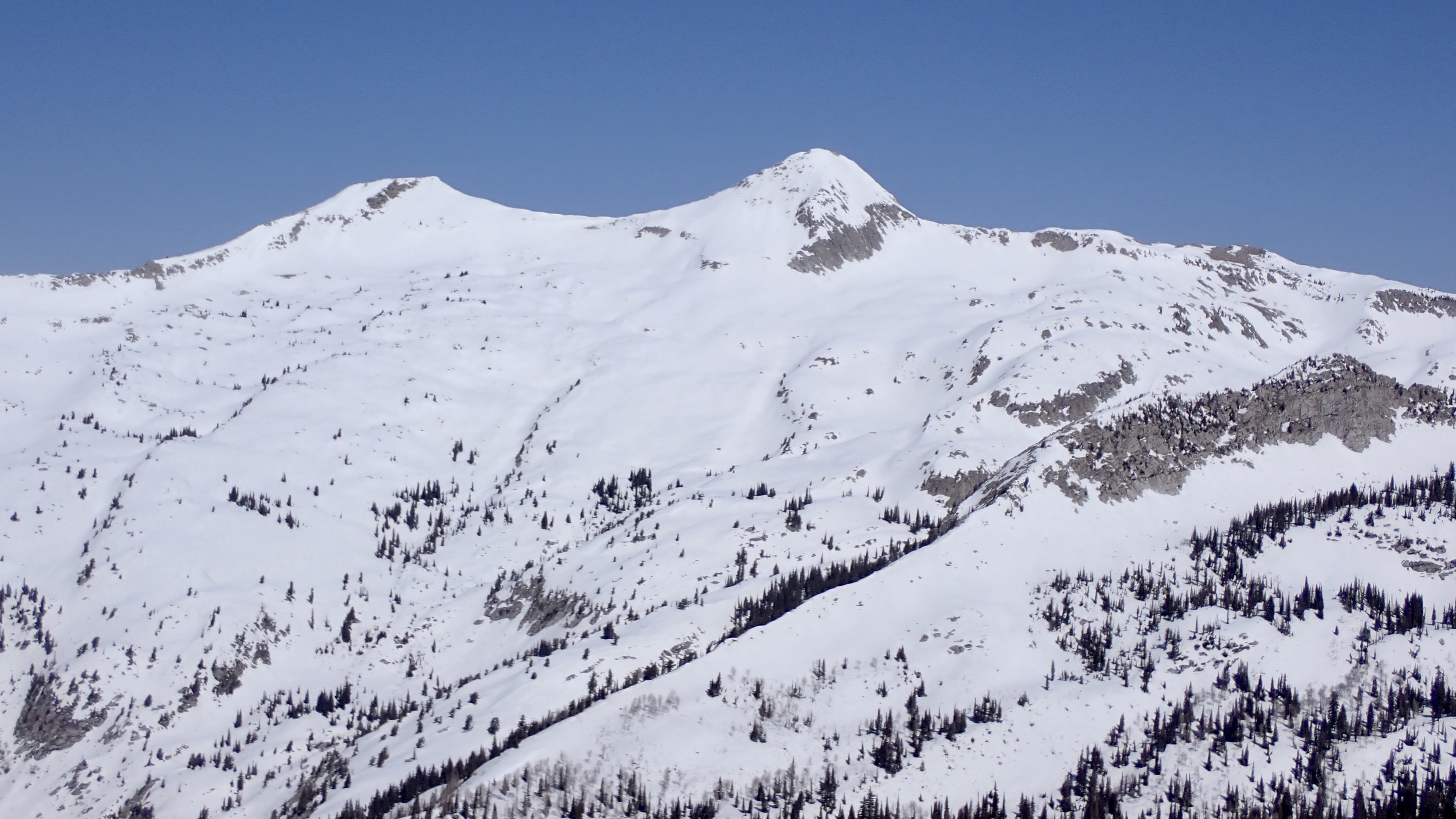
Excellent views off of the summit. Note the metamorphosed striated cliff band in the center of the frame.

Looking NE above Box Elder's scoured summit

Looking down into the "couloir" proper

The descent off of the summit required some negotiating through rocks and small rock bands. I chose skier's right, and Scott chose the more aggressive skier's left. Good on him-- he picked his way through the tricky sections with aplomb. I'm just happy to be here!


Scott working his way off of Box Elder's summit, with Happy Valley below

The first turn (especially the first heelside turn if you're a snowboarder) is always a doozy and this one was no exception. Luckily, conditions up high were relatively soft albeit a bit punchy. Once below the upper boney section, I was able to open it up and enjoy turns on marginal snow. Scott spotted a narrow little couloir toward the bottom of the descent and styled it. 


Ticky tacky jump turns through a hairy section

Airplane wings through the crux

Emerging unscathed

This was my first big descent in marginal conditions with my Atomic Backland Pros. The boot felt good for most of the day but really hurt my heel (currently dealing with nasty Achilles inflammation) on the descent. Back to the drawing board (or bootfitter?)!


The day warming up with much of the descent behind us

I'm the speck on the bottom right third of the frame. Box Elder's NW basin is stunning


We made soft, slushy fall-line turns down a gully that led us right back to our running shoes. Ideal. We transitioned out of ski mode and into hike mode about 6 hours in. Historically this has been the part of a spring mission where I'm cooked and absolutely ready to be done with the day. Thankfully my fitness is lining up nicely and I was able to enjoy the leisurely hike down Dry Creek in the warm weather. This being my first time skiing in the Happy Valley, I was charmed to hear one local at the trailhead say, "Holy Guacamole!" when we told him that we did in fact go skiing today. We were back to the truck in 7 hours. 

Thoughts:

- The NW Couloir of Box Elder is not much of a "couloir" so to speak since it lacks the tight, walled-in nature that I typically associate with couloirs. I would call it more of a face or a bowl. Regardless, its position is excellent and the boney/cliffy skiing off of the summit makes it engaging enough to feel like there are some consequences involved. 

- The excitement for spring skiing missions is at an all-time high right now. Typically I start to think about rock climbing and mountain running around this time, but things seem different this year. Maybe it was the rampant instability of the early season that left us relegated to mellower days along the Park City Ridgeline... or perhaps I'm just getting better and more dialed at this whole splitboarding thing. 

- Dry Creek is a beautiful drainage and there are plenty of diversions and sights to see. I picture spending more time back here in all seasons— especially mid-winter camping when stability is right. It's kind of amazing how one drainage south of LCC feels like it's "out there." I suppose that's what the Central Wasatch will do to you. 

- Admittedly I am not too stoked on many objectives in the Central Wasatch as far as spring skiing goes (with the exception of some stuff in White Pine). I think this tour heralds an urge to venture further afield and access zones that are harder to reach during the winter.

Monday, March 22, 2021

Cardiff-Day's Fork 3/21

Lane in Benson & Hedges


On Sunday, March 21, the first day of spring, I set out for a proper day of steep powder riding in the Wasatch; the first this season, as a rare-for-the-Wasatch PWL issue muddied most ambitious plans up until recently. I was accompanied by Nick and Lane, who both rallied after a long week of skiing in the Tetons and ripping the resort, respectively. 

I knew the conditions were going to be good but the storm kept delivering and my expectations were greatly exceeded. 


The not so elusive Benson & Hedges Couloir


We left the TH at around 7:40 and were at the bottom of Benson and Hedges a little earlier than 9. We waited around on the apron to let the first party clear and then began the booter. While booting, another party came in from the top. Not usually a big deal but the first skier was rad enough to spray us with snow on his way down. Luckily, his partner apologized for him, but let me tell ya, he was this close to getting a snowball straight to the noggin'. The Wasatch can be a proper zoo sometimes. 

From the top we negotiated a short section of rocky snow and the rest of the couloir was patchy deep powder atop old avalanche debris. Just manky enough to make you take your time but deep enough for it to feel fun. 


Big Nick ready to drop


Nick entering Benson and Hedges

The apron was some of the best powder riding of the season, and the only thing that could've made it better was goggles. I didn't anticipate a low pressure day so I left the goggles in the truck, but lesson learned: keep em in the pack. 

After the apron, we reversed course and headed back up the booter for a run into Days. After some deliberation we traversed further south and skied Days Draw proper, which was dreamy, playful, and so wonderfully deep. The nice thing about slide path/tree skiing is that it's so straightforward and fun! 


Spring in the Wasatch


Freeride Lane about to get technical

From the bottom of Days Draw it was heads down to the top of Main Days. The sun came out for the first time that day and we all threw on anti-glop and de-layered. This was short-lived, and we were back into storm mode within the half hour. This particular 2.5k climb took a bit out of me for some reason, so I plodded along behind Lane and Nick and dealt with some gastrointestinal issues along the way. So it goes. I'm still 4/4 in not needing to poop in LCC/BCC, so that's something to be proud of. 

From the top of Main Days we dropped into Hallway. Lane skied it this past weekend and opted for the high entrance to spice things up. From the lower entrance, Nick and I watched as Lane negotiated the small, mandatory cliff. Any skis are rock skis if you try hard enough!

Hallway is excellent moderate couloir skiing. This was my favorite run of the day. 


Freeride Lane anxious to scratch the hardware


Nick in the goods


Lots of gnarled pine in upper Days/Cardiff


After Hallway we set up toward the Ivories. It seems that with these two the last climb of the day is always a slog and today was no exception. Lots of trailbreaking and a bit of navigating in ping pong ball visibility to the ridgeline wore me out some, but I was happy to be on top of Mid Ivory and ready to rip. The sun came out for the second time of the day in a big way, exposing the beautiful west-facing cliffs of Cardiff and also allowing me to open it up sans-goggles. Another great powder run. 


After a mellow splitski down the Cardiff Fork road, we were back at the car in around 10 hours. The first day of spring well spent. 

Sunday, November 22, 2020

Northern Swell 50K

Once again I found myself executing a bonehead adventure with my bud Nick.

This time we decided to head down to the northern San Rafael Swell for a full value day of linking several wonderful sections of wilderness in the Sid's Mountain area. We were both somewhat familiar with the terrain, as I had spent some time earlier this year exploring the first section of the run, while Nick had some experience in what would be the latter portion of the run. 

The first weeks of November had me frothing to go splitboarding, but the snow situation deteriorated rapidly. As the week rolled on, it was apparent that Utah and most of the Intermountain West would remain high and dry after an otherwise promising start to winter, so splitboarding would have to wait. Thus, heading down south seemed like a reasonable thing to do. 

Nick and I shot several plans back and forth, pored over some maps, and agreed on a relatively casual but long-ish 20-25 mile run. I am woefully out of running shape and anticipated a limping finish, but nevertheless was stoked to get down into the desert and further explore an area that continues to capture my interest. 

On the drive in, we passed by the newly minted BLM Sid's Mountain Wilderness signs. Last time I was here, it was still a wilderness study area. Nice. 

Crisp, cloudless. Perfect late autumn desert running weather.

We left the truck around 8 AM and made quick time descending into the bottom of North Salt Wash. I was pleasantly warm as we jogged at a comfortable pace, hopping back and forth across the wash and passing several small beaver dams. 


We followed cairns up to Sid's Mesa, climbing the slickrock terraces at a steady pace. Soon after topping out on the nondescript mesa (which lacks any real trail save for a pack trails), we gained our bearings and headed southeast to Sid's proper. Running through cedars on the mesa was probably the most type-1 part of the day. Just classic high desert cruising on open mesa. 


Somewhere on the mesa, with Navajo sandstone domes in the back

We made it to Sid's Cabin in great time, having taken no real breaks until then, and felt fit, energized, and stoked overall. I'd like to think that ol' Sid spent a lot of time up here on the mesa with nothing but his cows and thoughts. It's people like him that make me want to keep the headphones in the car on long outings like these. I wonder what he'd say about this whole wilderness area concept.


After poking around the old homestead and having a quick snack, we headed straight east toward the head of Virgin Spring Canyon. It was tempting to drop in here, but we stuck to the original plan and continued further along the rim to seek an entrance into Cane Wash. 


The southern rim of the "Little Grand Canyon" afforded expansive views across the flats and buttes below: Oil Well Flat, Limestone Bench, Window Blind Peak, all dusty and useless. I love every bit of it.

We crossed an improbable section of canyon rim that pinches together between Virgin Springs Canyon and No Man's Mountain, and ambled our way along the rim searching for an entrance into Cane Wash. It turns out there's no obvious points of descent, but we found a saddle between Virgin Springs Canyon and Cane Wash that would lead to a somewhat convoluted descent. After a ~900ft descent into Cane Wash, we were off the mesa and in the cool, shady reaches of the canyon bottom.


Unfortunately, the aches, pains, and chafes came way earlier than scheduled. While I knew my body would break down at some point during this run (I had averaged only 7 mile weeks over the past few months), I was hoping to last a bit longer. 

After an extended break, some stretches, and a few Ibuprofens, I tried to jog along the sandy bottom of Cane Wash, but my IT bands were not having it. I felt great mentally and physically, but my knees were screaming. I was frustrated to say the least. Power hiking still felt fine, and we continued along the Wash Bottom at a fast hiking clip. 

A little bit of jogging, a little bit of walking. OHV tracks through most of the wash. Blechkkk.


We found a clear flowing stream midway through the wash. At this point, I was nearly out of water and decided to refill my bladder. The day before, I de-bunged my filter with some vinegar, but forgot to thoroughly rinse the vinegar out before packing it in my runner vest. In turn, the creek water tasted like old vinegar and was more or less undrinkable. The weather was cool enough to prevent any noticeable sweating, so I felt comfortable moving on without refilling the bladder. 


Cane Wash inspires


Right before exiting Cane Wash and heading into the San Rafael River proper, we ascended through a notch that split the sheer sandstone walls, saving ourselves some travel time. Daylight was still on our side, but we realized that we didn't have much of it left, and we probably would be finishing in the dark. Here's to hoping that the San Rafael River Stretch would go by quick!

This notch seemed like a very obvious spot for early inhabitants/canyon travelers to convene


The San Rafael River Stretch did not go by quick, and is the obvious contender for most type-2.5 fun of the day. At first it wasn't so bad, as we ambled through cattle pastures and along sandbars with empty dreams of getting to the mouth of North Salt Wash by dark. Soon, the pastures and sandbars became choked with brush and my legs started to get thrashed, so I switched back to spandex. A nice relief, and my IT band felt a bit better, so we managed some more jogging. After a while, though, the terrain became even more brushy, winding, and unfavorable to running, so we switched back to hiking. At current, we were at 20-25 miles, and realized that we would be covering much more ground than we had initially hoped. 

Still type-1-ish, though with dwindling daylight


Less type-1

We did as much canyon wall and riverbank skirting as we could, but we accepted the inevitable: we'd have to cross the San Rafael River. We were running out of daylight, and it didn't make sense to spend our time searching for improbable sneaks to avoid river crossings.


We moved as quickly as I felt we could. We knew that moving along the San Rafael River in the dark would be bad, since it was probably more than hip deep in parts. After a handful of icy river crossings, I started to become numb to the process (*ba-doom-ch*), and we pushed along, accepting nightfall and getting cold.


After the 6th crossing, we were very, very close to the mouth of North Salt Wash and dreaded the idea of crossing the river two more times. With the freezing cold creeping in and our fatigue levels rising, it seemed quite dangerous. After some canyon wall skirting, we reached a pinch point that edged off into what looked like a deep river pool, but we couldn't really tell by headlamp. Frustrated, we backtracked and searched for a means to get up onto the shelf above us. We found a climbable pourover and were soon sidehilling our way toward North Salt Wash.


We came across the first people we saw all day at the confluence of North Salt Wash and the San Rafael River. They had a camp set up and a small fire going. I was somewhat relieved to see them, but their words were anything but a relief: "North Salt Wash is a bit complicated and actually winds back and forth across the wash." Nick and I were hoping that North Salt Wash would be a breeze, so this was discouraging to say the least. 

I didn't even want to look at my map, knowing that it would do little to raise my spirits. Nick and I had a joke going, where Nick would occasionally look at the map and say, "We're making progress." Indeed. 

North Salt Wash was snowy overall, and we leapt across the narrow creek numerous times. We got turned around occasionally, but knew that staying more or less along the creek would bring us back to where we started our day. 

Cold, tired, sore as boils, we reached the North Salt Wash exit and started our climb up the slickrock and back to the unmarked TH I hadn't noticed how fatigued I was until this last climb. The final bit of walking felt dreamlike, and we were back at the truck in a little over 12 hours, cold and ready to eat. 

The entire route was entirely off trail (unless you count faint and inconsistent pack trails), and was the longest distance I've covered on foot in a single push to date. I am looking forward to more long distance desert efforts like this, but will do a bit more conditioning before the next one. 

The northern San Rafael Swell deserves all of the adoration, protection, etc. 

Total mi: 33
Total elev.: 3,366 ft. 
Elapsed time: 12:18
Food: banana, gu, 3 chews, pro bar, 2 clif bars, 8 macaroons 
Water: 1.5L
River Crossings: 6
Times Nick and I agreed that this was a "big ol' day": 50
Total amount of nut butter applied to the nether regions: 10 tbsps

Strava: https://www.strava.com/activities/4376552092

Baja Chronicles Pt. 4

 May 28-29 "Welp, we decided to punch it up north and hopefully find one last good Mexican wave before crossing the border.  Along the ...