I knew about the Wasatch Ultimate Ridge Linkup ever since I moved to Salt Lake City in the late summer of 2019. I began "trail running" the year before in Bozeman and very quickly took to the "light & fast" style of alpine and high country travel. As such, the WURL seemed like a logical objective on which to set my sights, and I completed small sections of the route during the next year and a half— either on splitboard or on foot.
If you live near the Wasatch and spend time in these mountains, then the WURL needs no introduction. This fine ridgeline hosts some of the most magnificent terrain the Central Wasatch, and as Jared Campbell accurately states, the route upon it is obvious and non-contrived.
Up until my WURL attempt, I had spent time in every drainage in both Big and Little Cottonwood Canyons. Closer to my attempt, I was putting up fast-for-me times on the South Ridge of Superior and logging the occasional 18,000' week of climbing. Moreover, a remote work schedule allowed for maximum flexibility in scheduling. If there was any time to attempt the WURL, it would be July of 2021.
Libby cruising the S Ridge of Superior, which makes for good training for the type of scrambling found on the WURL
And so I committed to giving it a go and practically obsessed over the route and logistics, reading every trip report and harvesting beta from friends who already completed the route. "The MC crux is easy when compared to S Ridge of Superior"... "Take advantage of fresh legs and Albion Basin"... "The Baldys are the crux" ... "The Notch sucks"... Noted.
I scoped the last section of the route—the Beat Out— a couple weeks prior with Vitor and Lane and felt really good afterwards; like I had more steam in the tank to keep going once the day was over. We spent around 6 hours of moving on the ridgeline proper. Would I have enough steam to theoretically complete that section 5 times back-to-back? I wasn't sure, and that was part of the appeal.
After a very mellow week of yoga, resting, sleeping, and placing caches, I got into bed at around 8:30 PM on Friday, July 2nd. I wouldn't get to sleep until at least 11:30 PM, but that was okay given I had slept an average of 9.5 hours each night the week before.
My watch alarm vibrated maddeningly on my wrist, and for a hopeful second I felt that none of this was real and that I could go back to bed. The reality was that the weather was good, the night was calm, and the WURL would be waiting regardless of whether I slept in. I forced down a bagel and some cold brew coffee and was off to Ferguson by 2:30 AM, blasting "John the Fisherman" and getting psyched for the first—and biggest— climb of the day up to Twin. I began walking at 3 AM.
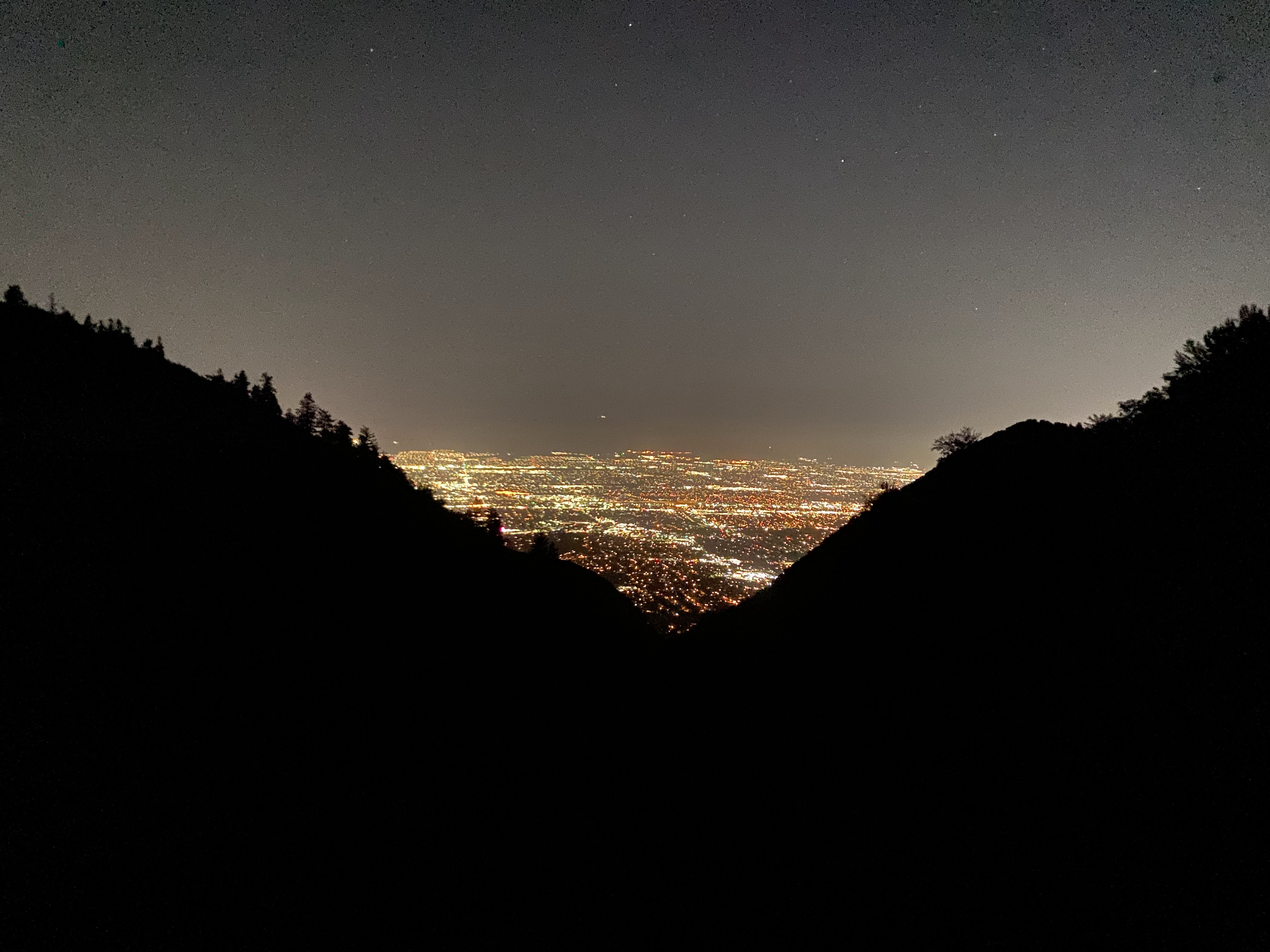
Ferguson was eery. I clapped loudly as I climbed to alert any large mammals, which were seen quite often near the mouths of the surrounding canyons according to several trustworthy sources. The claps resonated only briefly and were consumed by the dense canopy and towering rock walls of lower Ferguson. These moments were perhaps some of the quietest and most peaceful I've ever experienced this close to the city.
Climbing in a dream-like state out of Ferguson with the city lights below
I was passed by a very fast duo, one of whom was going for a sub-20 WURL time. One of them asked me if I saw the "cougs" down canyon, just above the rock walls. I had not, and shuddered knowing that such large and dangerous mammals were watching me so closely from above. Before passing, one of them told me they would yell very loudly if they saw any more "cougs" up canyon. I held my breath waiting for their yells, and sure enough they came. I turned the headlamp to high beam mode and minutes later saw several sets of eyes on the peripheries of the upper-Ferguson meadow. I'm no expert, but these looked like deer's eyes. In any event, there were lots of them and I didn't spend much time hanging around to investigate. I continued upwards, cautiously scanning the meadow with my headlamp.
I mostly nailed the climb out of Ferguson except for the last section leading up to the ridgeline, where I went a little far right and was forced onto some bonus ridgeline bw Pk. 9645 and Pk. 10350. It wear near sunrise and I turned my headlamp off. Feeling a bit paranoid, every little rattle and rumble of a loose boulder jolted me into alertness. I was ready to be done with Ferguson and on familiar terrain.
Ambling along the ridgeline above Stairs, I enjoyed a wonderful sunrise that illuminated the drainage's quartzite.
The climb up to Twin was uneventful. I had been listening to the classic 'Acid Rap' (comfort music) on my way up Twin and believe "Pusha Man" was playing while I topped out. Great energy. I ate some bars, sucked down some water, applied sunscreen, and texted Libby that I would be at the top of Monte Cristo in 4-4.5 hours.
The Cottonwood Ridge Traverse is excellent and makes a fine outing, whether preparing for the WURL or just looking to have a great day on the ridge
The Cottonwood Ridge Traverse was a lot of fun and I was in the shade for the first half of it. After Drom, I started to feel the high summer sun's power as it shone from above and reflected from the shiny quartzite. I knew I needed to cool down if I wanted to continue in high spirits. Luckily, I came across a snow patch and filled my bladder and gatorade bottle with snow, as well as my shirt and hat. This was a huge morale booster and I made great time to Pk. 11,033
Trying not to think too hard about how long it might take me to get all the way over there
Hot dogs or legs? I wrote the words 'lucky' and 'love' to remind me that attempting the WURL is an act of self-love, and that I'm lucky to temporarily put life on hold and enjoy outings such as these
I would be onsighting Pk. 11,033 to Monte Cristo (I completed a Twin-11,033 traverse last summer with a Mill B exit). I was nervous about the Monte Cristo "crux," but as it came into my sights, I realized it was very straightforward and I climbed it with ease, hooting and hollering with the exposure. Worrying about this crux took up a bit of a mental energy, and I should have taken friends' words to heart: this is considerably easier than any of the 'crux' moves on the South Ridge of Superior.
I was making great time and topped out on Monte Cristo around 8 hours after I began. I actually beat Libby and Grace to the summit of Superior (they planned on scrambling the South Ridge and bringing me "real" food on the summit). I waited on the summit of Superior for about 20 minutes, sucking down some Gu and applying KT tape on fledgling blisters. Seeing Grace and Libby only boosted my morale. I was feeling amazing, and we all agreed to take a more substantial rest down at my resupply near Cardiff Pass.
Looking forward to the mid-day cruise around Albion Basin
Grace and Libby providing much needed company and hummus
I stuffed down as much food as I could—mostly junk food and Coca Cola— without getting "full." I said goodbye to Libby and Grace, tackled the small bit of scrambling on Flagstaff, and then cruised up and over each of the smaller summits above Albion Basin. It was comforting to walk along tame terrain in good weather. I relaxed a little, listened to some Office Hours w/ Tim Heidecker, and contemplated my strategy for the impending night.
I enjoyed wildflowers all the way through the Albion Basin section and reveled in the fact that valley temps were likely much hotter.
All smiles on Wolverine; everything firing right and feeling good
As I approached the Point Supreme lift, I saw rain clouds boiling overhead and checked the forecast. It looked like a chance of rain about 60 minutes out—just in time for Devil's Castle, which poses some of the more challenging scrambling on the route. I texted Greg who told me about a potential exit right around Devil's Castle East in case the weather turned. I decided I would just take things as they came.
The ridgeline between Point Supreme and Devil's Castle was very annoying and loose, and I was excited to get on the relatively solid rock that Devil's Castle offers ("relative" being the operative word here). I topped out at 5:30, very ahead of schedule and wondering what the heck I would do when the night came and I needed to onsight Bullion Divide, solo and in a presumably exhausted state.
It seems like Devil's Castle can be casual or less-than-casual depending on how well one nails the route
Sugarloaf and Baldy were easy, and for the first time in the outing, I began to feel some fatigue on the uphills. Before setting out, I made a conservative estimate that I would arrive at Hidden Peak (and my second resupply) at 10 PM. Turns out that was quite conservative as I arrived two and a half hours ahead of schedule (arriving at around 16.5 hours). Along with food and water, I cached a small bivy pad and a cheap Walmart bag up there as a contingency plan. The Summit Lodge, which is located at the top of the tram on Hidden Peak, was open and I drank from the water fountain and washed up a bit in the bathroom. As I tended to blisters and stuffed my face with more junk food, people looked upon me like a vagrant. One asked where I was going and the only honest answer I could give them was "West along the ridgeline until it doesn't make sense anymore."
I made the choice to continue on—no sense in bivying here when there was still daylight and some energy left. I debated on whether I should leave the cumbersome (but compact) Walmart sleeping bag behind at Hidden Peak in favor of my small sit pad and space blanket for when I needed sleep (which I knew would happen; the only question was when and where). I chose to take the sleeping bag, which made the climb up AF Twins quite exhausting. At least there were some goats and a pretty sunset to provide some inspiration.
Daylight running away from me on AF Twins
I was getting tired, but there was no avoiding that. I made it most of the way down Red Stack before flicking on my headlamp. More than tired, I was stumbly and a bit cloudy of mind. The 3rd cl. trail down Red Stack felt challenging in my exhausted state, and I knew that if I wanted to complete the rest of the route in a safe, conservative style, I would need to stop somewhere and rest. Luckily, I found a bivy platform in between Red Stack and Red Baldy and made a comfortable-ish bed at around 10:15. I set the alarm for 4 AM and pulled my buff over my eyes.

I couldn't sleep. I was over-caffeinated and mentally stimulated. My mind was in go mode but my body wanted to chill. When I tried to sleep, I saw weird shit behind my closed eyelids. For example, one second I was negotiating a car purchase contract with Pee Wee Herman and the next I was coordinating WURL logistics. My jaw clenched. It took deliberate effort to keep my eyes closed. In between attempts at sleep, I would remove my buff and stare down from my bivy at the city lights. I kept thinking that the longer I lay down, the longer I was prolonging the WURL.
I remember snoring when my alarm sounded at 4 AM, so I probably got some very light sleep. I turned off my alarm and tried regaining some of that sweet, sweet release, which I must have experienced but could not enjoy. I laid around for another hour and a half, then gathered my things, ate some breakfast bars, and was on the move shortly before 6 AM. That bivy was unproductive, and I don't think I got much meaningful rest despite laying around for the better part of 8 hours. Takeaway: if I had to do the WURL again, I'd beg a friend to tackle the night with me.
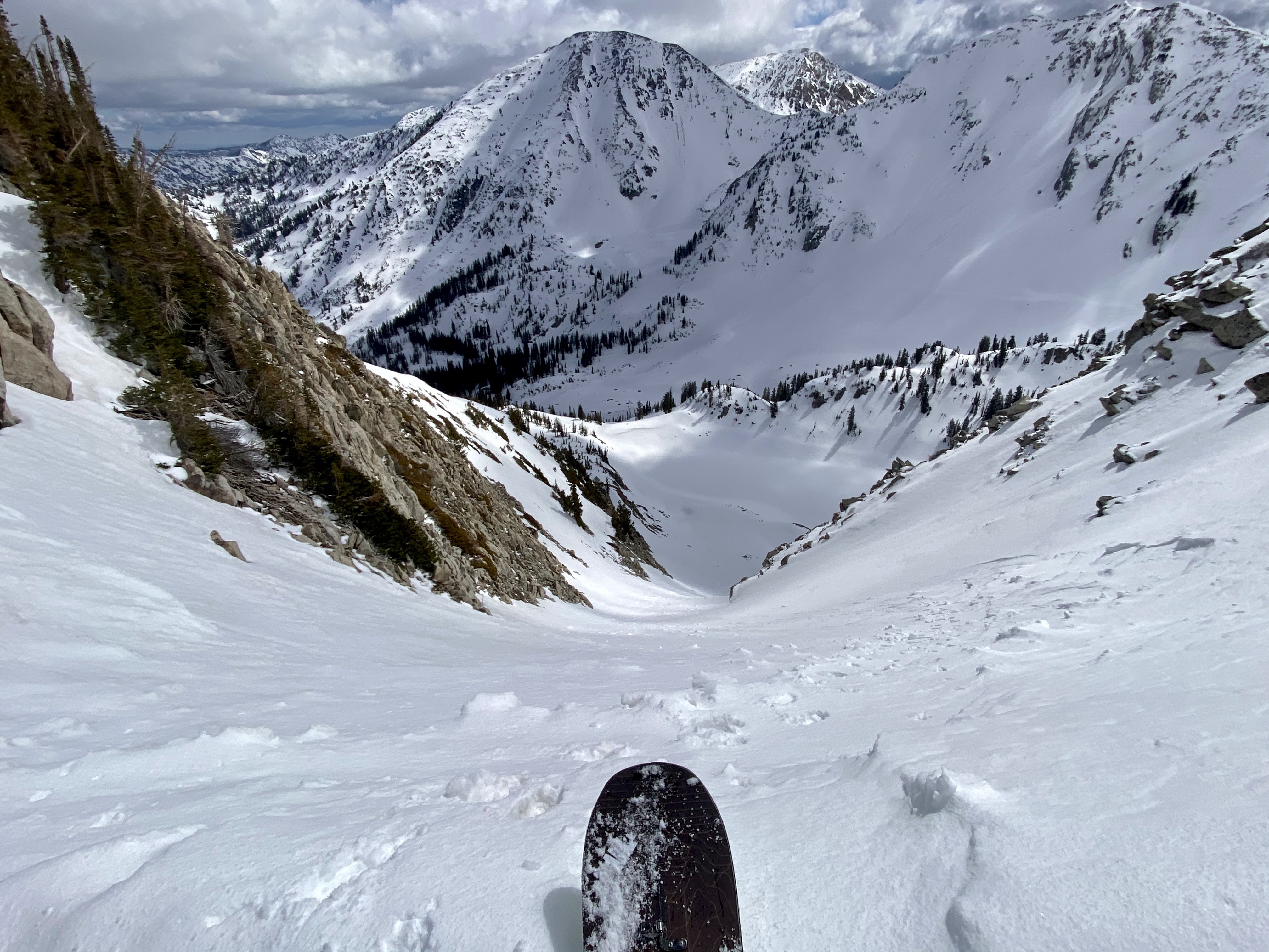
With the new day came the biggest mental and physical low of the effort. It was difficult to eat and drink, I was going at a tortoise's pace, and I had some gnarly GI issues that required perching over cliffsides in precarious pooping positions. I knew that White Baldy was some of the least enjoyable scrambling on the route, so I had that to look forward to on top of everything else.
Very drained on Red Baldy, but I knew that taking this picture would provide some perspective and give me something funny upon which to reflect
Between Red and White Baldy I ditched the clunky Walmart bag, knowing that I'd need to come back to this hard-to-reach cache some time before the snow falls. Oh well. I still felt wrecked, and I gingerly sipped on some carbonated yerba mate while contemplating the route up White Baldy. I chose a loose but straightforward ascent looker's right, and as these things go, my spirits rose and my energy was restored. I remember reading an Anton Krupicka essay with the overall message something along the lines of "it never always get worse." This was the case here. With a little faith and a 'one foot in front of the other' attitude, I persevered through my low and found myself in cruising mode once again as I reached White Baldy's summit.
All smiles on White Baldy. Compare with the last photo, only hours before
White Baldy took forever, and I found myself grateful for it to be over. The final stretch—from Pfieff to Lone— was all familiar and felt like an old friend. I ascended Pfieff with the crowds. It was Sunday and the 4th of July, so that was to be expected. I hung out at my cache for only a short amount of time, selected the foods that would join me to the finish, and drank as much water as I could stomach. Heading up the Pfieff, I chose the rockier section of trail on looker's right. To the left of me a hiker called over and said, "Hey! Have you ever done this before? It's easier over here." It was nice knowing that you could be in the finishing stages of the hardest outing of your life and you'll still have a hiker in a safari hat giving you routefinding pointers.
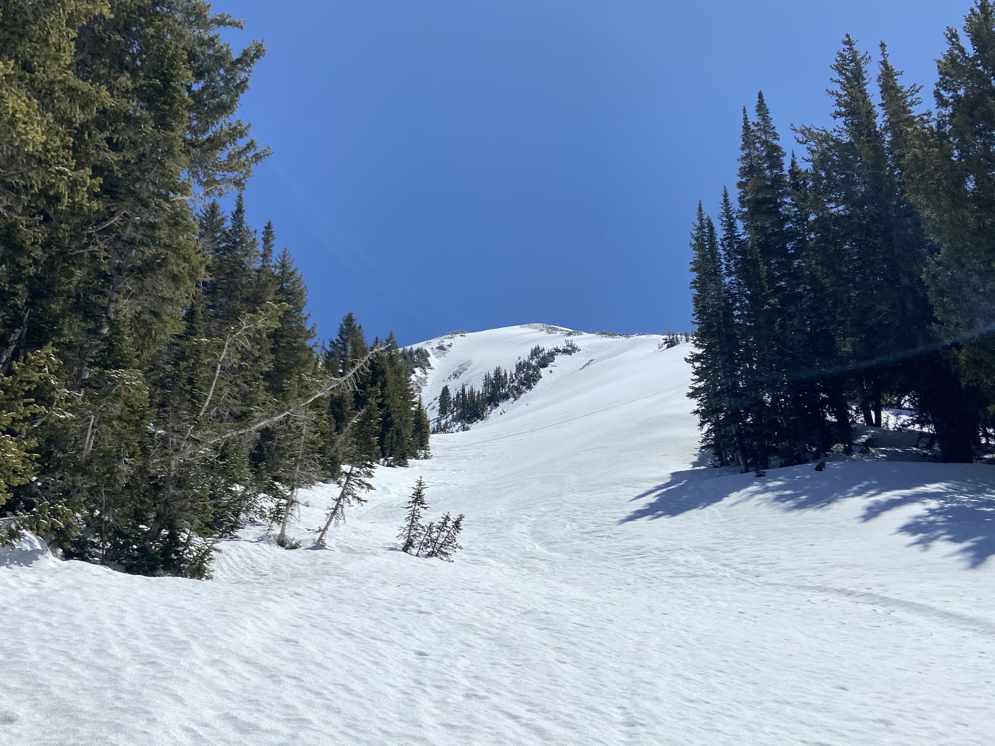
The Pfieff is stunning and its East Ridge is probably one of my favorite hikes in the Central Wasatch
It was HOT, and there was no breeze whatsoever. The sea of granite upon which I navigated began to feel like a solar cooker, and I couldn't reapply sunscreen fast enough. What's more, I was getting thirsty and every uphill felt laborious. I don't remember South Thunder feeling so tedious when I did the Beat Out a couple of weeks ago. This time, it was plain torture. Bighorn and Lone appeared so close it felt like I could nearly touch them, yet I needed to detour north to tag South Thunder proper. Due to the scorching temps and my waning stoke, I listened to some upbeat music (see: The Black Seeds 'Into the Dojo') and frequently sipped from my bladder hose. This only did so much, and I got a little off route coming down South Thunder which required some backtracking.
The "speed bumps" went surprisingly fast and I was at the base of Bighorn, psyching myself up for the final climb of the day. I was on my last liter of water and I still had Bighorn, Lone, and all of Jacob's Ladder (which I was unsure had adequate water) to tackle. I took some conservative sips, ate a couple of Gu's and bags of chips, and fired off the steep and engaging climb up Bighorn. I think I nailed the descent off of Bighorn as best as one could (something like left-left-right-left-right-right-etc.)—the cairns only helped so much.
This was it—the final climb to Lone, the final peak! I heard some water babbling at the head of one of the drainages on the south side of Lone, and found plenty of snowmelt trickles. I was stoked and took about 15 minutes to re-hydrate and fill my water storage up with cold, clear snow meltwater. Lone was uneventful in the best possible way, and I summited at 4 PM with some other climbers who had been spending the weekend in the Cirque.
Was Ferguson yesterday? Last week? In a past life?
I had exited via the Notch and Bells a couple weeks prior, and although the Bells descent was tempting, I did not want to deal with the Notch again so I chose Jacob's Ladder. I asked Libby if she could shuttle my truck to the Jacob's Ladder trailhead, which she so kindly did. Well, sort of. I made a bit of a research SNAFU and failed to discover that Jacob's Ladder TH had been closed, and that parking was a few miles further down canyon at Orson Smith. I wouldn't discover that until nearly at the Jacob's Ladder TH where I thought my adventure would end.
I gawked at all of the pretty rock in the Lone Peak Cirque (my first time in here) and felt like I had had enough ridgeline scrambling for the summer and that it was time to get on some more vertical rock. The blisters on my feet were practically unbearable at this point, so I ate a few Ibuprofen and resolved to powerhike all the way back to the truck with little complaint. Thankfully, my joints and muscles all felt great. I winced in pain with each step downward on the moondust trail that is Jacob's Ladder, but I was happy to let my guard down and enjoy watching some of the interesting weather that was passing over Draper. Turns out, Jacob's Ladder isn't the most straightforward trail from the Cirque, and I spent more time backtracking than I would have liked.
Moments like these I find myself asking why I choose to attempt things like the WURL instead of going rock climbing
About 3,000 feet down and nearing the Jacob's Ladder TH, I decided to turn my phone off of airplane mode and check my texts. I had just completed the WURL! To my chagrin, Libby informed me about the Jacbob's Ladder TH closure, and after some Google mapping, I realized that my adventure would be 1.5 hours longer than I originally anticipated. This was slightly soul crushing, and I began to regret not going down the Notch and out of Bells, where there was water and shade.
I made it to the Jacob's Ladder TH at 6 PM, and sure enough, there were no cars nor people. To add insult to injury, the gusty weather created dust/sand drifts and I was running out of water. I alternated between jogging and power hiking back to the car at Orson Smith, nearly stepping on a rattlesnake and hoping to avoid any cougars. I arrived at the truck at 7:45 with the entire adventure behind me and a potluck with friends to look forward to. I was surprisingly coherent at dinner, and went home to sleep the sleep of the just; the just plain tired.
Thoughts:
- The WURL certainly is my hardest and longest outing to date, and definitely will be thee adventure of the summer. The WURL has a lot of things going for it in terms of a reasonable objective on which to to set one's sights: lots of bail points, quick access to certain sections of ridgeline for caching, and easy access in general which makes forerunning sections a no-brainer. Moreover, all of the scrambling is approachable and common mountain sense should get you through the looser and harder to navigate sections. I consider myself having a substantial climbing background and felt very comfortable moving at a relatively steady pace over any terrain the route could throw at me.
- I spent roughly two or more weeks obsessing over the WURL, turning down some fun plans and events in favor of resting and getting in the right mental state for my attempt. It was a lot of work—both mentally and emotionally. I could see attempting an objective like this once every few years; there's no way I'd want to incorporate such an outing into my adventure itinerary on a seasonal basis.
- I was drawn to the WURL because I felt uncertain that I had the physical or mental strength to complete the route, even though I had completed almost every section. I knew I wouldn't do it fast, and thus I set out to prove to myself that I could remain focused and on my feet in the mountains for upwards of 30 hours. Turns out I am capable of doing that and then some. Some sections were fun, some sections were not. Ultimately, I learned that I could complete seemingly unachievable goals if I resolve to getting them done. It's a simply idea in theory, but it means a lot more when testing it on such an excellent traverse.
- Right after completing the route, I felt like a bit of an imposter; like I didn't actually 'earn' my finish and somehow scraped by or got lucky. Now that I've had some time to process, I'm satisfied with my finish and know that an adventure like the WURL has gotten me that much closer to my limits. I think knowing where this threshold lies is important and will help me in ways that are useful not only in the high country but also in life.