Sunday, June 6, 2021

Friday, June 4, 2021
Dark Canyon Wilderness Loop

On the second week of May, Libby and I set out for our annual spring desert backpacking trip. Although we love the Swell, we chose to venture further south to Bears Ears. On this trip, we traveled through all types of desert terrain and saw some of the most intact dwellings/ancient structures that we've ever seen. On top of that, we spent the entirety of each day moving and got stoked for more remote adventures in the upcoming warm months. Backpacking continues to be a great way for Libby and I to press the reset button on our lives and reconnect with ourselves and each other.
As Utah residents, we are incredibly fortunate to live only a short drive from some of the finest desert country in the world. These areas are vital for our wellbeing and their intactness preserves a heritage that Europeans spent years nearly eradicating. I always leave these trips feeling a tremendous amount of respect for the desert and whomever made it work for themselves in this unforgiving environment. Moreover, each trip into the desert makes me feel like this "public land" is not ours even though we as citizens technically own it. Indeed, I feel much smaller within the backdrop of the Intermountain West and know that I'm only a visitor in spaces such as these.
Travel was from the Woodenshoe Canyon, up Dark Canyon, and out Peavine Canyon. I didn't record our track, but I estimate the total stats to be around 4,000-5,000 feet of gain and anywhere between 45-50 miles. We completed the trip in roughly 3 days and we felt we moved quickly. With trips like these, we always wish we had more time to stop and explore.

Albeit a bit late due to a trailhead snafu, we started down Woodenshoe Canyon, which was dense and had some massive ponderosa pines.

We had lunch during the heat of the day at the confluence of Cherry and Woodenshoe. After eating I poked around looking for dwellings but couldn't find anything. We were out of the dense pine stands at this point.

Libby spotted this dwelling from the trail a ways between the Wates Pond area and Cherry Canyon.

Note the wooden beams and the windows. Incredibly intact.

I had never experienced rain in the desert until this trip. Luckily I brought my pancho. It looked like a weak system so we waited most of it out under a little overhang.

The dirtiest part of the water source at Wates Pond, where we set up Camp 1. A really lovely area.

Toward the confluence of Dark Canyon, the lowest elevation of the hike. Hot, dry, sandy, and eroded, wave-like rock.

Collared Lizard

Dark Canyon is DEEP! We looked up at some of the massive sandstone headwalls and daydreamed about coming back here with a rack and rope for some deserteering.

A granary used to store grains, seeds, and other forage. We looked around and thought about how collecting grains (let alone building storage) would be a massive project. No wonder why the ancestral people who collected them also wanted to protect them. Were these canyons wetter when ancestral peoples lived here?

Camp 2, a bit up-canyon from Trail Canyon. The established campsites were taken by a party of three who decided to spread out, so we had to find our own. We cowboy camped that night, and it was surprisingly cold. Waking up throughout the night and gazing at the stars sweetens the deal.

It started to feel more like 'forest' land once in Peavine Canyon. I wish we could've set up camp in one of the lovely, flat meadows.

Water was scarce on this trip and especially in Peavine Canyon. We sucked from some pretty nasty puddles. It tasted about as good as it looked. Unbeknownst to us, there was cleaner and more abundant water a bit further up-canyon. This was our last planned water refill until the cattle trough that we mistakenly thought was only a handful of miles ahead.

We boogied on sandy FS road under the hot sun through much of lower Peavine Canyon.
After some miles, we had little water left and were excited to set up camp in a spacious, shady pine grove. We realized that we misread the map and mistook a corral for the cattle trough filled with cool, clear water. This meant hiking up canyon until we reached the cattle trough, which could've been anywhere from 1 to 4 miles. We only had 1 liter of water apiece, which was insufficient for camp and the following morning, so we continued up canyon.

Libby was dealing with some gnarly blisters, so she told me to go ahead and set up up camp once I found the trough. I moved heads down until I could find the cattle trough, but I did periodically look up and appreciate the airy aspen groves in upper Peavine.

Water! And some level space for camp! In my opinion it's poor form to camp this close to a water source, but it was late enough in the evening to assume that no one else would drop by.
We built a small fire and listened to a couple of great Snap Judgment stories before heading off to the tent. We wanted to soak in as much of Peavine Canyon before returning back to civilization.

On the final day, we anticipated easy trail for the entire way back to the trailhead. I was breaking in my new shoes (dumb thing to do on a trip) and wanted some respite, so Libby and I both hiked in our camp shoes. I've got some goofy (but light!) water shoes, and Libby's got some plastic composite Birkenstocks. Nice one.

Upper Peavine was such a treat. Very fine high elevation wooded mesa.

More of the same. Note all of the beautiful lupine. A trail runner's dream.

Aspens in upper Peavine.
We finished up the trip cruising the few miles of the well-bladed FS road back to the Woodenshoe Canyon TH. Spirits were high, but we knew that we would either need to break my car window or figure out a way to unlock the car from the outside. That trailhead snafu I mentioned before? I locked my keys in my truck. I spent a lot of time on the hike thinking about what a dumb mistake that was. Thanks to the inReach, we found out that we were in way too remote of a location to expect the FS or AAA to help us out for cheap.
I really did not want to break my window (we still had lots of traveling to do, including a drive to the Front Range), so we decided to spend a few more minutes devising a way to get into the truck without breaking anything.
Those few minutes were some of the more dramatic in recent memory. After some deliberation, we unlocked the car from the outside! I won't go into detail, but it turns out that all you need is some wire (in our case, cattle fence wire) and a pot scraper.

Victory!

Both of us were overjoyed and we drank the shit out of some cooler-cold beers and soaked up the high desert sunshine.
Next stop: a cheap motel in Durango.
Sunday, May 23, 2021
White Pine Rambling
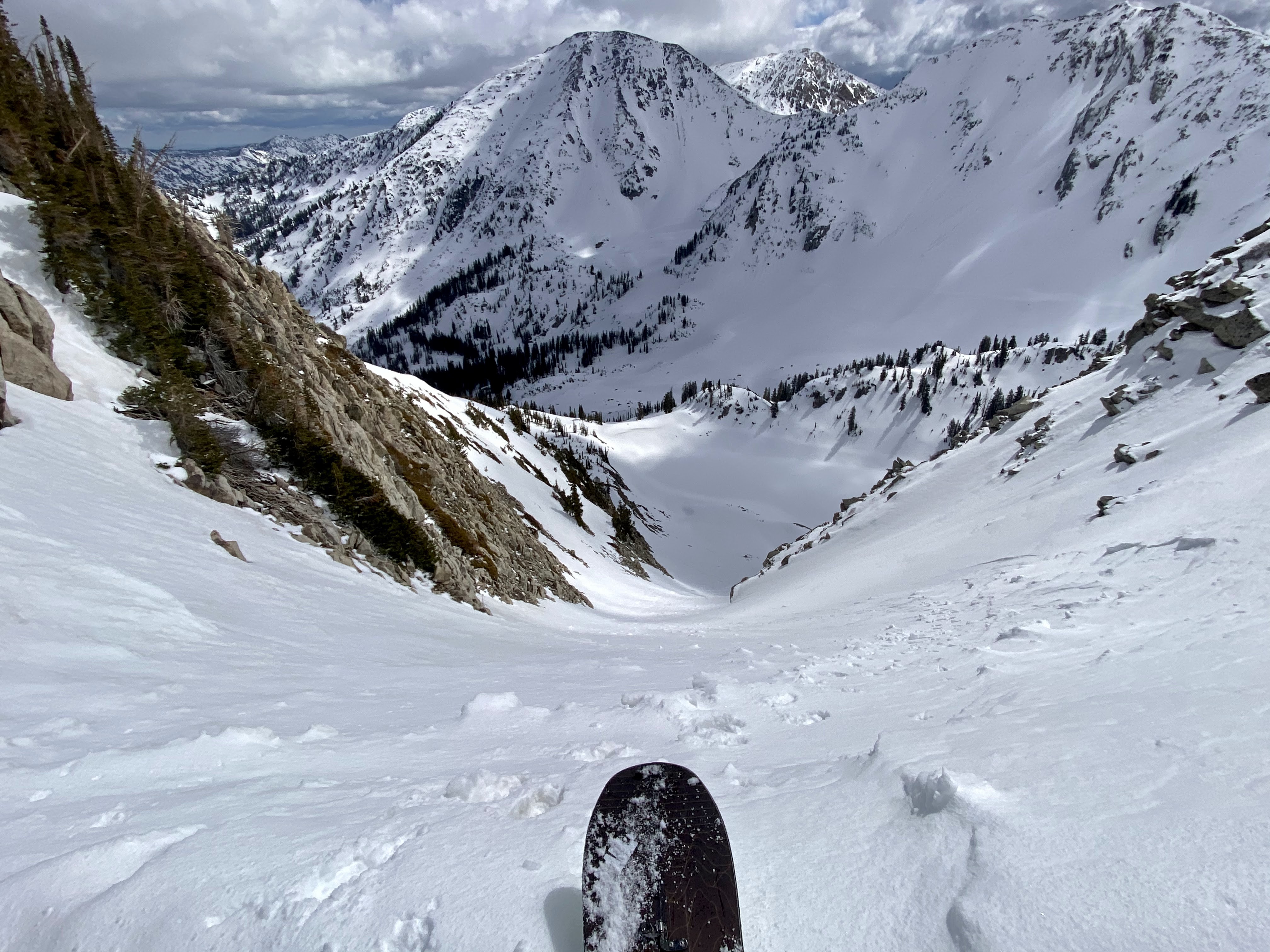
Ready to drop into Lake Chute
White Pine is one of those drainages that I often daydream about, but with this being only my second season in the Wasatch (and a very high danger one at that), I've mostly stayed away. This May, I was able to take advantage of a relatively light final exam period by heading into White Pine on three separate occasions. I didn't have a hard and fast plan. Instead, I would reach tree line and choose terrain that made the most sense in terms of snow conditions.
Lake Chute, Lake Peak May 4, 2021
I started the tour noticing a soft refreeze at about 8k and followed the White Pine Road to the meadow, arriving in about 1:15. As I emerged from the gully, I noticed about 5-10cm of trapdoor crust on top of wet, stale corn. Not inspiring. Boulder Basin looked tempting, but the snow surface on N-NE was still firm and I was hoping to nail some better, softer snow on the SE-facing Lake Chute.

Boulder Basin looking good
A party ahead of me finished skiing Boulder Basin and told me that it was okay and that Lake Chute looked a bit choppy but could be better by the time I drop in. I skinned below the flanks of Boulder Basin until I reached a cornice overhanging the apron of Lake Chute. Switching to booting was necessary and quite bad. The trapdoor crust over junk corn persisted and I was up to my crotch in lousy spring snow the entire way up the Chute. I arrived on the summit of Lake Peak in 3:06, which likely would go much faster in better conditions.

Red Baldy and Red Top from the top of Lake Chute
The upper section of Lake Chute was moderately steep in the high 30s/low 40s and firm. I made choppy turns over chunder and punchy snow all the way down to White Pine Lake and began the very easy and enjoyable egress down the White Pine Road and back to the trailhead. This was the first day I broke in my CiloGear 45 pack, which worked surprisingly well as a daypack. It's steadily becoming my go-to workhorse...
NW Red Baldy, Red Baldy May 6, 2021
Back at it again with a slightly later start than a couple of days ago, I noticed another soft refreeze as I climbed the White Pine Road, but stoke was still high.
At the meadow 5 minutes quicker than last time due to having the road and skin track a bit more dialed, I had my sights set on Red Baldy. I was at the base of NW Red Baldy an hour later skinning up very firm yet edge-able crust (no trapdoor this time, thankfully). Noticed some large debris piles on my way up. Gulp.

Looking cross-drainage at Lake Chute

Due to very firm, exposed, and annoying skinning conditions, I transitioned just shy of the summit, which I arrived at in 2:45. Again, this could go much faster with better conditions. I'll blame it on a lack of ski crampons. I've made an honest attempt at finding them in the past, but it turns out that hardboot splitboards require specialized (see: more expensive than necessary) ski crampons. It's tough to get splitboarding gear this season so I've had to suffer.

Looking down-drainage at the next day's objective
NW Red Baldy rode exceptionally firm but thankfully smooth with little chunder. This is an excellent moderate ski run and I would love to come back and ride it in better conditions.

The top of NW Red Baldy fairly locked up

Looking back up at my firm descent
I was back to the snow-covered creek (which was melting out fast!) in 3:05, the meadow in 3:15, and the car in 3:40.
NW Red Baldy, Red Baldy; Birthday Chutes, Red Top May 8, 2021
With finals behind me, I had a long Saturday planned and hoped that this spring snow had a bit more time over the past couple of days to come into better shape.
It didn't. But that's okay because I managed to cover a lot of ground and get eyes on some lines that I certainly would like to return to in the future.
With much colder temperatures in the forecast, I opted to start the day at 8 AM, hoping that this would set me up for some softer descents. Thanks to a very motivated party on my tail on the White Pine Road, I made it from the TH to the White Pine/Red Pine fork in :23, and the meadow in under 1:00. I was doing well on time and it was still cold so I decided to check out Icefall, a SE-facing line off of Red Baldy.

Looking across canyon at Twins and the north side of LCC
I wasn't really up for firm, exposed skinning today so I took the skis off early and started booting. I got my eyes on Red Baldy's N couloir, which looks like an excellent and somewhat cryptic descent. I'd like to ride it one day, but I'd probably want to go from the bottom up or ski it with someone who has done so before.

The upper section of Red Baldy's N couloir

Loving Red Baldy's narrow NW ridge with great styrofoam snow
I noticed that another party had ascended Red Baldy's SW ridge before me and arrived at the top of Icefall. I watched all seven(!) of them ski it and felt hopeful as I traversed across Red Baldy's cruxy and fun NW ridge.

Aesthetic ridgetop booting
I arrived at what seems like the true Red Baldy summit in 3:25 and made a quick transition atop one of the micro-entrances into Icefall. It was about 11 AM, but the S-facing snow on the ridgetop felt perfect. I was delighted to drop in to a line that I heard so many great things about.

Looking down one of the many entrances of Icefall and into Silver Creek
And so I was disappointed when I made several turns and kicked off very wet, unsupportable mush about 12"+ deep. Not only would I need to descend the line with these deteriorating conditions, but I would also need to ascend out of Silver Creek and over East Pass, which is all S-facing. I had no desire to shave my margins this close despite watching a party of seven ski it without consequence, so I bailed. In my opinion, wet slab was definitely a factor.
As such, I down climbed Red Baldy's summit, strapped in, and traversed over rocks into NW Baldy to ski that line once again. Very similar conditions to the last time. At the apron, I cut hard skier's right with hopes of getting Tri Chute in decent conditions.
Unfortunately the lower portion of Tri Chute looked thin coverage-wise and the choke was filled with avy debris. My last option was Birthday Chutes, so I continued traversing skier's right until I reached the NW ridge leading up to the top of the chutes.
My stoke eroded when one of my skins failed. The glue would not stick despite multiple warming efforts, so I resolved to booting the ridge all of the way to the top of the chutes. This really sucked, as more trapdoor crust made the last 1,000 feet go painstakingly slow (roughly 1 hour).
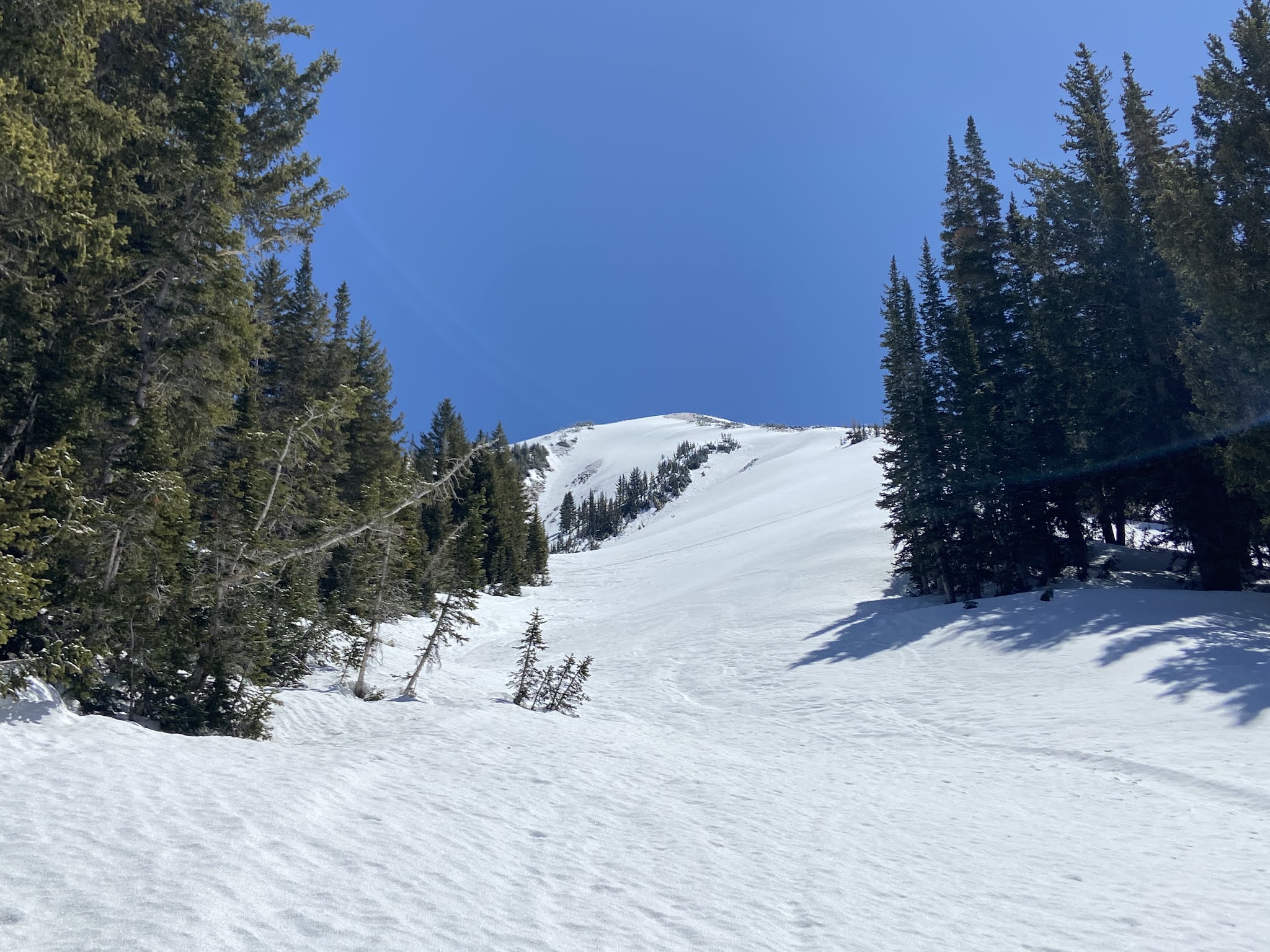
Looking up at a grueling bootpack/posthole that I will repress from my memory
I was quite gassed at the top, which I arrived at in 5:45. I stopped for a long break, fueled up, and realized how cold and windy it was. No wonder why N-NW never really came into shape.

I descended one of the Birthday Chutes (the second one from looker's right) and really enjoyed the lower sections above the White Pine meadow, which were pleasantly soft and fast.

Firm turns down one of the Birthday Chutes
Thoughts:
- Conditions on the north side of the compass never really came into shape during this week, and that was fine with me I suppose. While spring conditions offer relative stability, nailing down good spring conditions is complicated. I'll continue to stick to the old "you don't know until you go" adage.
- White Pine is one of those places where I can say with utmost sincerity "It's just good being out here." That adage would define these outings since the riding was never that good, but the aesthetics were top notch.
Monday, May 17, 2021
Getting Away With It on Twin

On Saturday 3/27/21 I had an excellent day linking a pair of lines on Twin: the E Face, which I had rode the previous year, and the NW Couloir, which was new to me.
Based on the day's conditions, this was a daring day of backcountry skiing. I've learned a lot from this outing and have since dialed it back. Much of the details about our decision-making are relayed in this observation I submitted to UAC. For the sake of brevity, I will refrain from reiterating what I've already stated in that observation. Read that if you want some more context.
Anyway... Early in the tour we noticed wind-loading on the E Face from the W-SW while skinning up the drainage. I expressed concerns, and my partner and I agreed that we would continue to reassess the situation as we neared Twin.

Under the E Face we deliberated between booting the face directly or ascending via the south ridge. I suggested booting the E Face because it was fast and I had done so last season. This was the 'Familiarity' in FACETS in motion. Just because I had booted the E Face without hiccup last season does not mean that it would be good to go on this day. This was poor judgment on my behalf and I am glad we did not choose this option.

Photo by Lane
As we gained Twin's south ridge, we noticed a wind slab crown about 10-15' wide and 8-10" deep. We booted the bed surface, gained the ridge, and got into ridgeline mode.
The first thing we noticed on the South Ridge was a wind slab avalanche on the SW bowl below the party before us' (Party #1) bootpack. It didn't seem very big, but little did we know it caught and carried a member of Party #1. Again, we followed in the footsteps of Party #1 and continued on toward the summit.
While on the summit crest, we watched Party #1 ski the E Face and kick off multiple small wind slabs. They successfully descended the line without getting knocked off of their feet. Since we had planned to ski the E Face, we took this is a good sign, but I think FACETS was at play again in the form of 'Acceptance,' 'Commitment or Consistency,' and 'Social Proof.'

At the top of the E Face, each of us made hard ski cuts and kicked off a small pocket of windslab apiece. At this point, we felt that we had properly flushed our line, but continued to ski very conservatively and in short pitches. The descent was a sharky base-scraping mess, and the only quality turns were found on the finishing apron.

A sharky E Face

Photo by Lane
At this point, we were motivated to get on top of Twin again and check out the elusive NW Couloir. There was no more wind at this point, so I thought that any potential damage had already been done.

I traversed across the entrance to the NW Couloir and kicked off a wide but shallow wind slab, which flushed down into the couloir. This would be the last wind slab we would kick off that day.

Contemplating the NW Couloir

Lane in the NW couloir's narrower section

Exceptionally fine snow quality

photo by Lane


About as aesthetic as it gets. The NW Couloir is right up there with the greats

Looking down the N Fork of Deaf Smith and into Salt Lake Valley


After an elapsed 11 hours on the go, we were back at my partner's house waiting for Libby to shuttle us back to our cars at the S-Curves in BCC.
Thoughts:
- We made A LOT of decisions this day, and I think we got away with some of them. Particularly, we were lucky to arrive at the south ridge after Party #1. If we arrived first, I think we would have gone forward with the bootpack up the ridge. In that case we might have been the group to trigger the wind slab and the consequences could have been much worse for us. It's so hard to say whether this would be the case, which brings me to my next point...
- The attitude I employed on this day is inconsistent with the attitude that I would like to employ every time I go out into consequential avalanche terrain. I like to think that my overall strategy in the mountains leans toward conservative decision-making with an eye on the long game rather than the pursuit of short-term rewards. (This is a rough interpretation of a chart I saw in 'Staying Alive in Avalanche Terrain,' but bear with me) If we travel in avalanche terrain every day for 100 days, we need to make the right decisions 99.99% of the time if we want to survive a lifetime of skiing in avalanche terrain. I am certain that I lack both the knowledge or experience to make the right decision 99.99% of the time, and thus I must turn around or choose safer alternatives when faced with uncertainty. The odds aren't in my favor otherwise.
- E Face ALPTRUTH: Avalanches? Yes; Loading? Yes, wind; Path? Yep; Terrain Trap? Yes; Rating? Low; Unstable Snow? Yes; Thawing? No. Five of the factors were present, so the odds were not in our favor here.
- NW Couloir ALPTRUTH: Avalanches? None observed; Loading? Yes, at the top; Path? Yep; Terrain Trap? Yes; Rating? Low; Unstable Snow? Yes at the top, no lower in the couloir; Thawing? No. This one is less clear cut. It seems we were right on the cusp. In any event, decisions made on the cusp are not the ones that increase your chances of surviving in the backcountry.
- I think we were both motivated for a big day on Twin, and that certainly affected our decision-making. It would have taken more than just some shallow wind slabs to get us to turn around. But like Noah Howell said, high motivation gets parties in trouble. Indeed, a shallow wind slab carried someone off of their feet that day, so conditions were not as 'manageable' as we perceived.
Subscribe to:
Posts (Atom)
Baja Chronicles Pt. 4
May 28-29 "Welp, we decided to punch it up north and hopefully find one last good Mexican wave before crossing the border. Along the ...

-
 I knew about the Wasatch Ultimate Ridge Linkup ever since I moved to Salt Lake City in the late summer of 2019. I began "trail running...
-
 May 28-29 "Welp, we decided to punch it up north and hopefully find one last good Mexican wave before crossing the border. Along the ...
-
 Law school has ended, and a few months back Vitor and I talked about doing something adventurous during the first week of May. Due to variou...